Tuesday, July 31, 2012

31 July - Day 91 - East & Northeast Towards the Border

From Valley RV Park (Mile 1662.8) to saddle on ridge between Black Mountain and White Mountain (Mile 1683.5)

Total PCT Miles hiked today: 20.7

Pan here.

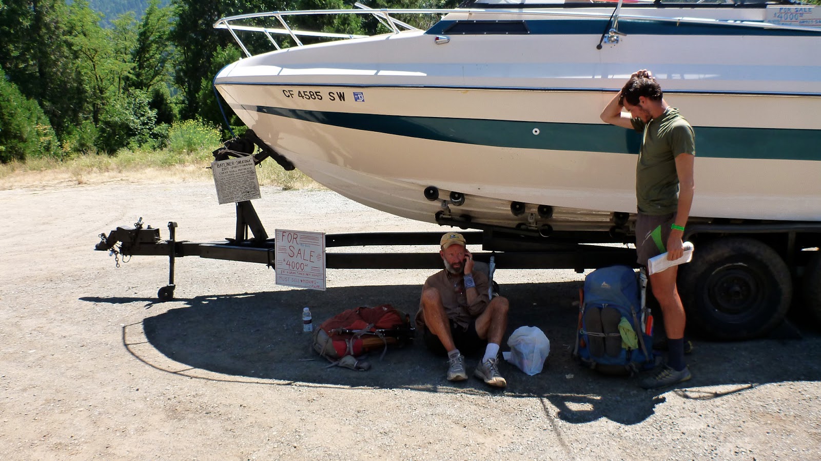
We enjoyed a mongo breakfast at the Seiad Valley Café where we sang "O Shenandoah" for our waitress's birthday. Our fantastic cook was also happy we sang, and we were glad. She took great care of us. We did not, however, take up the pancake challenge.

Seano, the shutterbug, catches a photo of Pan and Dionysus outside the general store.

We hiked past abundant roadside blackberries (yum!) to the trailhead back into the Klamath National Forest climbing 5,500 feet (!) back to the 7,000 ft level to continue our turn now north and then east toward the border with Oregon.

Seiad Valley down below and the big bend of the river. Yesterday we hiked down the mountain road on the far left of this photo, then followed the River to the bridge. Here we are on the mountain above it getting near a good spring.
Up on the mountain at the first spring (thirsty!), we saw Fierce Melon and Tailgate with their fry pan. Jugs was ahead of them on the trail somewhere. The guys were taking turns lugging the fry pan, they said, while Jugs was in charge of being cook and frying the pancakes.

Far up and over, the views of Shasta from the west side were impressive!!! Wow!

Lunch with Tailgate, Jugs, Fierce Melon, Bone Lady & Swiss Cheese at Kangaroo Spring. Beautiful -- but a little challenging to find the water down in the meadow (turned out, a better source was uphill ahead on the trail a bit, and on the left).

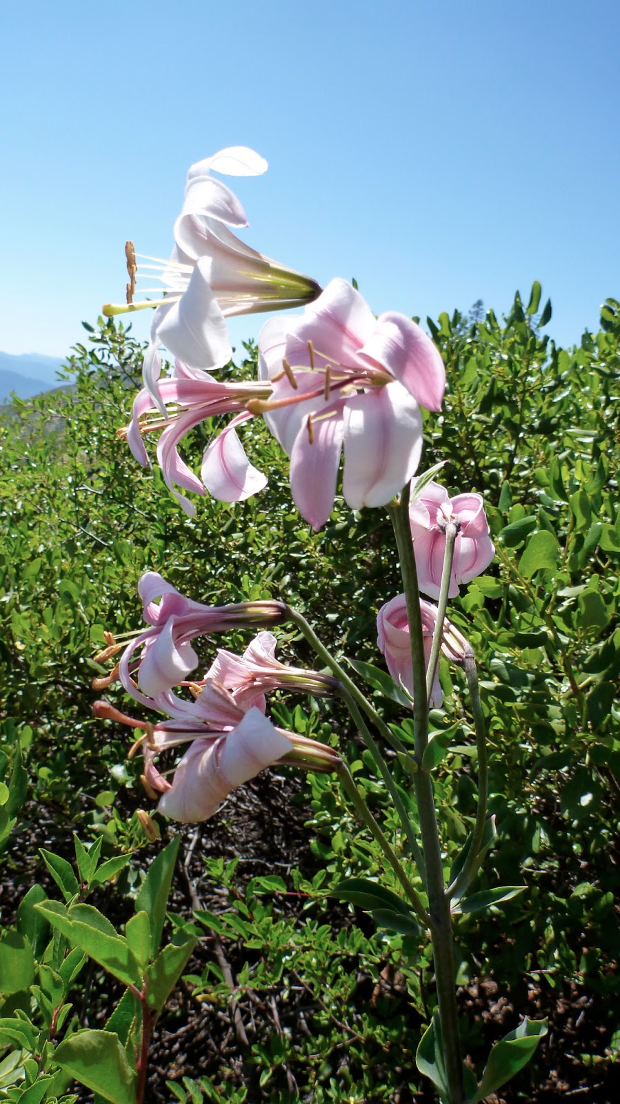
Cascade Lily. What a flamboyant flower for the mountains!

Dinner at Beardog Spring. Log to sit on, and a great meadow with Cornhusk Lilies tall and blooming all over. We find a lily leaf folded into the braided trickle of the spring and it funnels the water right into our bottles. Beautiful! We sit up on the long log -- and then along comes Bone Lady and Swiss Cheese. We make our Rahmen for dinner and rest a bit. We sit on our jackets, since our butts have lost their fat and even sitting on logs hurts. But what a lovely spot.

Nice camp on sparsely wooded ridge with strong winds - Lavender ridges to northwest with salmon and coral atmospherics as sun sets. Cozy in tents with rainfly against the wind. Sweeet.

Our tents in a makeshift clearing with amazing views to the west. And wind.
Evening views to the northwest from our campsite.


- Posted using BlogPress from my iPhone

Monday, July 30, 2012

30 July -- Day 90 -- Beautiful Descending

From Three-fork Fir Campsite by Buckhorn Spring (Mile 1640.8) to Seiad Valley RV Park (Mile 1662)

Total PCT Miles Hiked Today: 21.2

Pan here.

Ouch! We got up at 5am under the giant three-pronged White Fir (we are calling it Yggdrasil), and I made mocha lattes in the dark by headlamp while Seano & Dionysus got packed up. Our trail buddy, Tom Sawyer, also was packing. All of us wanted to reach the Seiad Valley before 2pm when the café in the tiny town closes.

That meant we'd have to pound out 22 miles in 7 hours. Our pace is good but not speedy anymore -- given the fasciitis Dionysis and I are currently struggling with (and, to be fair, even with foot pain Dionysus could zip down the mountain much faster than Seano & I manage). So we set off -- and eat no breakfast and take no breaks for seven hours. Hard going - and the heat increased as we descended. [And we are rushing so, we forget to take any photos].

But what beautiful deep forests met us as we went. The tall moss-furry conifers got taller & taller -- and the understory greener and full of ferns and flowers and berries. The voice of the winter wren tinkled and tumbled among the silent pillars. The polished russet skin of the madrone trees caught the filtering sunlight in a glow.

On the road walk into town -- hot hot hot -- next to the river, what blackberries tempted us! Yum! But we couldn't dawdle, since we were running out of time to make it to town food. Signs of NO MONUMENT and STATE OF JEFFERSON sprouted up here and there. Lots of anti-government signage together with conservative political slogans. Odd.

A local stoner (who works doing "trimming" in the marijuana industry) offered to give us a ride as we neared the town.

We made it to the café just in the knick, and ordered hearty sandwiches. Seano had a chocolate shake and I had a root beer float while we waited for our sandwiches. Lots of eating ensued. But Tom Sawyer had fallen far behind and we hadn't seen him for awhile, so we picked up a club sandwich and fries for him from the café. [It turns out once he realized he wasn't going to make it in time, he slowed down and enjoyed the bumper crop of roadside blackberries along the way].

We staggered over to the campground and rested a bit. We had descended more than 4500 feet over the course of 20 miles. Tomorrow it will be an ascent of the same magnitude -- but in just 9 miles, and the slope faces the hot sun. By all accounts tomorrow -- a scorcher according to the weather service -- will start off punishing. But then it's only two and a half days to Ashland, Oregon. Wow. In two days we cross the 1700 mark -- and we'll have less than 1000 miles before us.

So we are camped under the maples on the lawn of the campground -- among about ten other thru-hikers scattered about -- and anticipating an early start. The store-owner next door has made an extra run to Yreka for restocking (apparently about 90 hikers came through during the weekend and (like locusts?) depleted the store's inventory. So we'll revisit the store at 6 am, and have breakfast at 7 o'clock. On the trail by 8?

It'll be getting hot, we reckon.


- Posted using BlogPress from my iPhone

Sunday, July 29, 2012

29 July - Day 99 - Drovers & Rovers

From Shelly Meadows (Mile 1617) to Three-fork Fir Campsite (Mile 1640.8)
Total PCT Miles hiked today: 23.8

Dionysus here.

More and more I've been thinking about the way the experience of the trail is illustrative of a postmodern sense of time - the fracturedness of experience moment to moment, etc. You might think at first that the trail, as an unbroken line on a map, might conform to a linear sequenci and cohesive experience for us. That you can easily track what happens. That you become so attuned to your surroundings that you can almost predict what will happen next. Not so (at least for us). In fact, despite walking every step of the way across a single line of trail we find our experience to be hardly continuous. It is more like a kaleidoscope of shifting images and perceptions that allide across and into one another almost gracefully and almost without sense or reason.

For instance, we woke this morning to a whole herd of cows munching on grass next to the trail and clanging & clunking the cow bells around their necks extra-loud. As we set off we scared he cows into a single file run away from us/in front of us on the trail. So we spent the first two miles driving a bunch of cows as they bawled in protest and tried to push past each other even on the increasingly steep slopes. It was absurd and unrepeatable and totally unexpected.

Tom Sawyer, Pan, and Dionysus (with Seano at the camera) driving cattle along the trail.


And next thing I knew the cows were long gone and I was enjoying a bowl of Cap'n Crunch (always a good idea on the trail).
Us with Tom Sawyer for trail-side breakfast.

Then a kid, maybe sixteen passed us with his shirt off and a revolver siting in one of those funny breast holster strap things.

Then a beautiful lake.


Then we enter the Marble Mountains Wilderness where he wild flowers are as tall as our heads and we start crossing snow fields again for the first time since the Sierras.

And we end the day next to be most remarkable fantasy-sized white fir with three trunks. We pitch our tent directly beneath it. The lichen and moss bob in the breeze and too many tree arms stretch out over us as I write. Unspeakably magical AND majestic and unforeseeable.

Searching under the giant White Fir for where to put the tents.


And tomorrow will be something new and unexpected and just as difficult to piece together.


Saturday, July 28, 2012

28 June - Day 98 - from Etna to Cowbells!

Sawyer's Bar Rd (Mile 1606.5) to campsite at Shelly Meadows (Mile 1617)

Total PCT Miles Hiked Today: 10.5

Seano here.

Wonderful to stop early today at an excellent creek-side campsite.

But I'm jumping ahead. This morning, after a good night at the B&B in Etna -- and after a marvelous breakfast on the veranda served us by our hosts – we treated ourselves to ice cream at the quaint soda fountain, in the town's old brick drug store. I finally found my first chocolate malt in 1600+ miles of the trip. I had hoped to drink malts from the bottom of California to the top but I'm thinking it's a flavor that has gone out of style. Anyway, we caloried up, did our shop 'em up, and returned to the Hiker Hut to repack.

We were happily surprised to find Rubylocks there, and then Last Minute and Grits rolled in. Tom Sawyer was there, too. It was great to hug their necks, Last Minute's especially since we haven't seen him since Mammoth Lakes. We're still trying to talk him into relocating to Boulder and look forward to having a chance to hang with him again in these next sections. And our dear, fabulous Rubylocks!

Dave, our host, drove us up to Etna Summit, and we hiked out with Tom Sawyer. He and Pan talked nonstop for nearly four hours about everything from botany to relationships. Dionysus and I talked about the nature of the trail -- this line of experiences and landscapes and people we're stringing together from Mexico to Canada. Scissors Crossing and the rest of Southern Cal seems long ago and far away as we close in on the Oregon border; and yet they belong to the same piece of life we're in the process of hiking into existence. As such a powerful metaphor, the trail, Dionysis said, can't help but take on a life of its own. And so it has.

Early bed. Nice creek. Good weather. Not great miles - but what we planned.

Great campsite next to a full-flowing creek with wildflowers and many sites. Tom gets a fire going for awhile, but we're soon in our tents (away from mosquitoes) and enjoying our books.

One of the tents set up among the trees.

I don't know what non-hikers see in a photo like this, but we immediately see CAMPSITE!!! Sweeeet.
 Now what to do about the endless clunking and clanking of cowbells as about 15 cows graze the browse in the meadow by our tents? Earplugs.


- Posted using BlogPress from my iPhone

Friday, July 27, 2012

27 July - Day 97 - Russian Wilderness & Klamath National Forest

From ridge above Wolford Gulch at 7156 ft elevation (Mile 1580.2) to Sawyer's Bar Rd (Mile 1606.5)

Total PCT Miles Hiked Today: 26.3

Pan here.

Yet another marathon. Uff.

We hiked into the Russian Wilderness today. Very impressive! We have turned north now -- our westward movement almost done. Oregon isn't far away.


We saw a new tree -- Weeping Spruce -- today. Wow! What a peculiar beauty! We've been seeing Grand Fir for the past week or so -- its needles smell like freshly sliced grapefruit. Now that we are in the Klamath National Forest, we keep alert to the ways the flora is Pacific Northwest in its articulation. Flowers are in full blossom now -- the summer in high heat. We are grateful for the elevation, since even up here the heat gets oppressive as we lug backpacks up and down ridges.

The views in the late afternoon and evening to the west are always of rank upon rank of mountains made blue by moisture haze in the air. Gorgeous atmospheric perspective!

At the end of the day we came down to a mountain road.

Ten miles away north along this road is the remote little town of Etna. By all accounts it is hiker-friendly and worth a visit. We also need to resupply our food (we find we can no longer carry many days of food since our caloric needs have so steadily increased).

We wait about an hour for a lift. Just about zero traffic on this mountain road.


Then a pickup with three dogs in back stopped and we hopped in back. What a tongue-licking we got with our salty, sweaty, schmutzy faces. But joyous fun for us! Dog therapy.


The little white dog was so excited, he just kept humping the big brown & white in a non-targeted, dizzily absent-minded, but tenacious manner. That, with the wind whipping around, and the truck zooming zigzag down the mountain road at speed, and the young Lab licking everyone in the face, the big brown & white absolutely covering our faces with her huge tongue,  and all stumbling and bounding around, made for a tumbling, messy, and chaotic ride --  hilarious, actually, though this photo catches Pan at a particularly vivid moment.
At the Hiker Hut and Alderbrook B&B, we check in for B&B bedrooms (having phoned ahead for reservations), then head quickly down stinky and dirty on bikes and down through town to the brew pub to get supper. It was going to close in a half hour! Ooooh, did our legs object to cycling! Cute town.

Live music. Big outdoor patio filled to capacity. Brewpub overflowing. Great service from the New York waitresses. The place was crowded to the max (it's apparently the only show in town ... and the only one for miles around), but we got in -- sat at the bar at first, then a table opened up and the waitress got us seated and our orders zipped into the kitchen just in time. We ate heartily. And what impressive beer offerings!

Our good hosts at Alderbrook B&B took good care of us -- gave us a great deal. We got our showers, and tucked ourselves into big comfy beds. Outside, the Hiker Hut was filled up and overflowing. But we were insensible now ... aches & pains at the end of a long day, and deliriously happy over the texture of, oooooh, pillow cases!!!!

We watched some of the Olympics opening ceremony on TV, then it was off to sleep. Tomorrow morning, after breakfast, we must get groceries.

G'night.


- Posted using BlogPress from my iPhone

Thursday, July 26, 2012

26 July - Day 96 - Malevolent Enchantment

From ridge above Chilcoot Creek (Mile 1552.7) to ridge above Wolford Gulch at 7156 ft elevation (Mile 1580.2)

Total PCT Miles Hiked Today: 27.5

Pan here.

Today we continued on through the impressive Trinity Alps Wilderness. What views!


But another marathon day took the starch out of us. All three of us felt like we were hiking in a cranky, ill-humored haze. Is there some local troll or gnome we pissed off? Ugh. We all did our footsore work, though -- and in such a lovely landscape -- and lugged our tired asses uphill and down until we camped.

Our calves, shins, ankles, and the bottoms of our feet are aching most nights now by the time we go to bed. Earlier in the trip it was knees, hips, and thighs. Our feet have stiffened so that they are crazy tight every morning -- the fascia from metatarsals to heels strung like guitar strings. Twang! Ouch!

The skin on the soles of our feet and our toes has calloused such that they feel like goat hooves. Dionysus, Seano, and I have toes on both feet that have been numb now for weeks. This isn't unusual among thru-hikers.


- Posted using BlogPress from my iPhone

Wednesday, July 25, 2012

25 July - Day 95 - Another Day, Another Marathon

From high ridge camp (Mile 1525) [at elevation 6677] to ridge above Chilcoot Creek (Mile 1552.7)
Total PCT Miles Hiked Today: 27.7

Dionysus here.

Woke today in one of my favorite campsites of the trip. Wide open ridge with views of Shasta and the mountains we've hiked out of to the southwest. Good, restful sleep. Sean saw 22 shooting stars. Morning sunrise and coffee in tents. A slow and enjoyable start to the day.

Sunrise and Mount Shasta from our sleeping bags. Photo by Seano!

Seano's morning face.

Pan and Dionysus packing up.


The trail in this section is quite remarkable. Although it winds in and out of several valleys bouncing from one side of a ridgeline to the other the trail stays at virtually the same elevation throughout. We spent the entire day between 7000 and 6000 ft. -- great it makes for easy hiking at a comfortable pace and level of effort.
Seano and Pan having Second Breakfast (breakfast cereal and instant whole milk!).

Our hiking buddy Data got out of camp early this morning in order to have time to swim at Deadfall Lake this afternoon. We ended up missing him there (he had evidently moved on by the time we got there). But the lake was beautiful. We ate lunch on the ridge overlooking it.
Dionysus refilling water. Cornhusk Lilies growing here let us know we're getting up to higher altitudes.

We also ran into our own personal trail magic at the highway crossing in the evening. A naked section hiker and his friend passed us while we ate dinner -- and we cheered him on -- and when we got to the highway/trailhead a couple hours later, they were at their truck getting set to leave. They hailed us and gave us a beer for dessert. Thanks guys, never did get your names but we so appreciate the magic!

Pitcher Plants -- but we preferred their local name of "Cobra Lilies"
The last leg of he day was a bit death-marchy as we hiked on and on looking for a place to throw the tents. A wet valley full of mosquitoes was our first option -- after 9 pm and already inhabited by five or six sleepy thru-hikers. Not our preferred sleeping habitat. Finally we humped up a ridge and found a perfect spot for sleep. The mosquitoes harried and bit us as we set up our tents -- and we felt exhausted and aggro when we finally climbed in. Tequila all around!

There. Another fine day.


- Posted using BlogPress from my iPhone

Tuesday, July 24, 2012

24 July - Day 94 - Westwards through the Cascades

From Highway 5 (Mile 1506.5) to high ridge camp (Mile 1525) [at elevation 6677]

Total PCT Miles hiked today: 18.5

Sean-o here. A slow start out of Shasta this AM as we pulled together our food and freshly washed clothes for the next stretch. Plus we loaded up on breakfast at the Best Western, packing on calories.

Pan here : Our middle-aged, graying pony-tailed cabbie -- with a dream catcher depending from his rear view mirror, and ethereal Hindu-accented recorder music playing -- blessed us on our forward journey.

Dionysus here: back up into the beautiful mountains. Mt Shasta towers over all the wrinkled landscape around it. The mountains we hike through all day never really get higher than 7500 ft. So our eyes are drawn over and over to the huge and snow-crowned volcano. What charisma this mountain has.


We hike up onto and then past Castle Crags -- a dramatic mountain made into a wilderness area. Here's a photo of it from a distance:

Castle Crags.

We continue to hike up and up until Castle Crags is actually at eye level and most of it down below. We find a dry camp (no water) high up on a mountain ridge with great views of Shasta. Data and some other hikers have set up their sleeping bags here and there. We set up ours. And read for a little while (laughing with our good Terry Pratchett).

Thru-hiker eating dinner in his sleeping bag not far away. The sun has set. Shasta still has some last sunshine on it. The PCT passed up and around Castle Crags on the right and then onto the neighboring mountains up and up until we reached this ridge.


Posted using BlogPress from my iPhone

Monday, July 23, 2012

23 July - Day 93 - Zero day in Shasta.

By unanimous agreement, we decided to zero in Shasta. We can really feel the effect of day after day of miles ... Our feet and legs -- and more importantly our psyches -- feel the growing fatigue. Must rest and restore.

Beard trims. Hair cuts. Spa sitting. Coffee runs. Grocery resupply runs. TV watching. Relaxing relaxing relaxing.

Data slept on our floor last night but he headed off to take up some other thru-hikers on a free bed tonight.

Tomorrow, it's back to the trail.


- Posted using BlogPress from my iPhone

Sunday, July 22, 2012

22 July - Day 92 - Shasta Town!

From ridge camp in the woods (Mile 1493) to Highway 5 (Mile 1506.5)

Total PCT Miles hiked today: 13.5

Pan here.

We got up with no water for our coffee, so broke camp early and headed down to find a spring. But town food started calling to us, so we skipped coffee at the spring, drank water instead, and kept banging out the miles. What a strange and wonderful descent! Beautiful woods clinging to the steep mountainsides that our narrow trail neatly cut across.

We crossed the 1500-mile mark!

We pass the 1500-mile mark!!

Pan phoning a local taxi in the shade of a boat for sale. Sunny and hot!


After 13.5 miles, we reached the bottom. We crossed the Sacramento River on a broad bridge and faced a freeway. What to do? Hitchhiking on a freeway is tough.

We hiked on the freeway (with a policeman's permission) to the next off ramp, hiked down it to the frontage road, then by road and trail we hiked to the town of Dunsmuir. There we drank beer and ate ice cream at a gas station convenience store, and asked about rides to the town of Mt Shasta, 13 miles away.

We finally phoned a cab, and soon were off to town.

Shasta. Interesting town. The cabbie gave us a DVD of his guru teaching Eastern Enlightenment, Shasta style. We noticed lots of crystal shops ... a small town with LOTS of shops selling crystals. And the gray-haired men in town had ponytails. And facial hair. And lots of paintings on the sides of buildings of the 14,179-ft tall Mt. Shasta looming to the north. According to our cabbie, some local spiritual groups worship the mountain. "Shastafarians." We could understand, in a way, why. It has such visual & emotional impact.

Checked into our hotel, picked up our packages (though this Best Western had returned most of of our packages saying we should have notified them ahead of time. VERY frustrating -- and unlike other hotels on the PCT.


Seano at the hotel.
Sean's new shoes next to his current ones!
In town, we saw Dirty Brown, a few other hikers, then later bumped into Data and got food & drink at the local pub where he had just been eating & drinking; he stayed and chatted and drank some more.

Then we headed back for laundry and showers and all the other necessities. Data hung out in our room -- and drank beer. That evening the five of us went out for Dionysus's birthday meal at a lovely little restaurant. The restaurant turned out to be a dud. Argh.

Most aggravating.

Oh well, back to the Best Western for rest. [How compulsively we watch any old stuff on TV -- the visual stimulation is entertaining all in itself, despite parts of our brains protesting how vacuous the content of whatever movie it is. Oh well.]

- Posted using BlogPress from my iPhone

Saturday, July 21, 2012

21 July - Day 91 - Happy Birthday, Dionysus!

From Ash Camp on McArthur River (Mile 1476) to ridge camp in the woods (Mile 1493)
Total PCT Miles Hiked Today: 17

Here's a view in the morning from our camp:


Today we celebrated Dionysus' 26th birthday, the old geezer.

First ripe berries today (blackberry and thimbleberry)! A few blackberries and many thimbleberries. 

Still rolling through the moist river valleys south of Mt Shasta, with towering Douglas-firs and green understory of ferns, dogwood, maples, and poison oak. We wash in and drink from beautiful, bountiful creeks and rivers. We cuss at mosquitoes, biting flies, and midges.

For his birthday Dionysus got a glow-in-the-dark fairy wand, bird cards, and other accessories as stand-ins for his birthday gift: a finely prepared meal in Shasta.

We hightailed it to the tents as a cloud of biting insects moves in our camp -- and soon we were chuckling away as we read Terry Pratchett novels. Birthday tequila helped, natch.

Tomorrow, we hike 11 miles down to the freeway, where we must find a ride into the town of Mt. Shasta, for a resupply and for rest & relaxation (we'll be there 7/22 and 7/23). Yay!


- Posted using BlogPress from my iPhone

Friday, July 20, 2012

20 July - Day 90 - Mt Shasta in all its glory!

From Logging Rd (Mile 1444) to McArthur River (Mile 1476)
Total PCT Miles hiked today: 32

Wake up to wet sleeping bags and gear! Heavy dew atop the mountain overnight. Yuck. Pack up after coffee, then on we go. But what views of huge snow- and glacier-covered Shasta! So impressive. We think each one is the best possible. Then, wow!


The trail hugs high rims and ridges for half the day giving us an easy hike in the 7000-ft elevation range at first, surrounded by Douglas-fir and white fir. The path quickly enters woods that are lusher and greener!

It's been getting this way ever since leaving Burney Falls, but today is more so. Soon the trail is crowded and overgrown by lush growth of underbrush and flowers. The bracken fern is 4 ft tall at times. The white lilies are sometimes taller. Wow. As we hike west across the rolling mountains of the Cascades towards the Siskiyou Range, the woods look more like Pacific Northwest (and pan-boreal north hemisphere) wet montane. We are hiking through logging territory now.

We stopped around lunch, laid out our sleeping bags, our tent footprints, etc. It looked like a gypsy's yard sale. We ate and took a quick nap.


Trail dropped to the 5000-ft range, then plunged down, down, down to below 3000. Such deep beautiful woods -- with towering Douglas-fir reaching impossibly high. We were now entering a moist west-facing river valley, and the life is luxuriant. Creeks and springs are delicious. But the air got warmer as we descended.

One of our biggest-mile days so far. Having accomplished 32 miles of hiking, we stumbled into camp after dark -- very footsore, and not at all patient with the two rattlers already lounging in our campsite. Campfires from car camping tourists lit up circles of steep forest above the roaring creek below.

I thought maybe another campsite would be better, since there had been rattlers in the first we tried. So I left Dionysus and Seano resting, and went down to check out the next one. I tottered and weaved as I walked (your body loses the ability to balance without the backpack on, after a 32-mile day). Why didn't I take my headlamp? It was getting dark fast. I could make out the flatness of the ground -- the lay of the land -- with trees all around, but couldn't make out the details of what was on the ground. I bent over to see if this was a branch on the ground in front of me that I could reach down and tug out of the way, then I thought of rattlers and stood up suddenly -- and lost my balance and stepped back. Right at my feet the buzzing of a rattler erupted, and I did a high-stepping, knees up under my chin, frantic dance trying to get away. I'm not sure, but I think I stomped the poor rattler to death because I couldn't get my balance stumbling around and it suddenly stopped buzzing. I left that campsite at a run (ooooooh, my legs didn't want to run), and returned to our first spot where Seano & Dionysus waited.

"Well," they asked. "Was that spot any better than this one?"

"No, not really. I guess this one will do okay. Let's set up our tents, though, and zip them shut. Y'know. So nothing crawls in at night."

We set up camp, staggering around and pretty irritable.

PS. Getting up to pee in the night this time involved the unusual addition of a headlamp.

- Posted using BlogPress from my iPhone

Thursday, July 19, 2012

19 July - Day 89 - Old Friends

From McArthur-Burney State Park (Mile 1423.5) to Logging Rd (Mile 1444)

Total PCT Miles hiked today: 20.5

Pan here.

The night last night was warm and humid. Uncomfortable - but at least we were out of the mosquitoes and off the dirt for a night. The romance of the wilds has long since given way to hard-eyed realism. We love the trail - but not for fantasies of wilderness. For its reality. And sometimes that reality likes a break, a respite.

Rain clouds! Wow. First time since May 25 that we have seen them. The past several days we've had clouds moving by and puffing up beautifully, but not precipitating anywhere. But all we got was scarcely enough sprinkle to settle the dust -- and the dust in a volcanic landscape is considerable.

This is our sink, our fountain, and our bathtub. Everywhere we go now.
Landscape moved from one kind of volcanic (more or less recent) to another (old). The old stuff is fertile and richly growing with woods and flowers. What a list we could write here of all the old friends we are seeing in bloom. Many of these guys I learned 30 years ago from the reincarnated St Francis of Assissi, the magnificent Rev. Ernie Zoerb. He was 49 years older than I, and much I learned from him (including a sourdough hotcakes recipe he learned from old Pacific Northwest loggers in the 1920s, who themselves brought the recipe from the 19th century, where they had learned it from old prospectors). These flowers were his hiking buddies whom he greeted with laughter and delight whenever he saw them - and so I learned, and now so do we all. It's a form of literacy to be able to read the natural history of the life around us in the wilds, and it becomes an entry point for deeper engagement and embrace. Old buddies like Twinflower, Starflower, Claytonia, Pyrola, Pipsissewa are bringing back memories of long hikes with Ernie in the Bitterroots and the Montana Rockies. Niiiice.

Leopard Lily, I think. A new buddy of the trail.

Exhausted Dionysus napping against a pine tree during a break, next to some small grand firs.

As it was getting dark we still hadn't found a campsite, so we stepped off the trail onto a logging road in the deep woods high up in the mountains. A logging parking lot (we presume) -- a dirt flat spot cleared in the trees for logs to be piled and then loaded up -- served as our campsite. We cowboy camped under the stars, and the night was warm enough that buzzing and whining flying things pestered our ears and faces throughout the night.

Mosquito-netted Pan reading in bed.

Wide-awakes in the night while thru-hiking is not uncommon. So many aches and pains. And there the stars are above us. Seano and I remember how we "told time" by the stars wheeling during our long trek with Tuaregs across part of the Sahara. We had 12 hours of night then. You spent a lot fo time with your face to the night sky. Here, too, we pay attention to the stars. We try to doze, try to sleep, then roll over and check the sky to see how much time has passed. Word of advice: don't trust the Big Dipper or Little Dipper to tell you much. That's like watching the hour-hand of a clock to see if time has passed. You have to keep an eye on Taurus or Hercules or Cygnus. Those are the minute hands. They'll tell you the truth about the night. And this night we had the flash and zip of meteorites streaking on and off. I guess they're the second hand of the clock. They, also, don't tell you much -- but what fun to watch.

G'night!


- Posted using BlogPress from my iPhone

18 July - Day 88 - Trudging footsore across volcano effluvia

From Cache 22 on Hat Creek Rim (Mile 1397.8) to McArthur-Burney Memorial State Park (Mile 1423.5)

Total PCT Miles Hiked Today: 25.7

Pan here.

We are now averaging 21.2 miles per day. That's good! That means our daily distances are big enough so that the lower mileage we make on resupply days doesn't pull us down.

The lava walking is hard on our feet -- though we're still grateful for cooler temperatures than the norm this time of year.

We zoomed along across what seemed African savannah in Lassen National Forest ...


Passed the 1400-mile-marker.


... until we got back into wooded and greener mountains. Views of Mt Shasta continue to bring us to a stop, pointing to the north and exclaiming "Lookit that!"

And at Burney Falls we found ourselves in a huge wooded state campground crowded with tourists -- campers, motorbikes, tents, cabins, etc. We bought a six-pack of Shock Top Belgian wheat beer and ate sandwiches and hot dogs on a picnic table (ooooh, picnic table!)

I arranged for a bunkbed cabin for us and even talked the girl at the counter into bringing around the golf cart to give us a lift to the cabin with our packs on the back. Her boss objected -- and then I talked her into it, too. Whew.

Seano, lean and serene at the campground cabin.
Seano's legs, feet, and shoes. This is our reality!
Seano's brown arms -- and dehydrated skinny hands.

We then we ate some more, got showered (coin slot shower -- keep feeding it!), washed our socks & underwear in the bathroom sinks (how the kids stare at scrawny, bearded, shabby men in stinky shirts with holes doing laundry in public sinks. Can't imagine why.)

To bed!


- Posted using BlogPress from my iPhone